


Contact Info
PO Box 248
Wiggins, MS 39577
- Phone:
- 601-928-5291
Description
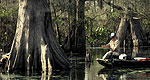
Black Creek, with it's deep, black water and white sand bars and colorful vertical bluffs, meanders through the De Soto National Forest with trees and flowering shrubs hanging over the banks.
Mississippi's only National Scenic River flows for 40 miles of within the National Forest. Plants flourish and wildlife abounds. Wood ducks and otters are often seen by those visiting the stream. Primitive camping is allowed all along the stream within the National Forest and a number of trails can be accessed near the river.
Details
Camping Info
Day-use fee - $3 per vehicle for a group of 4 or family; each additional person is $.50
Additional Details:
High on a bluff overlooking Black Creek7 miles downstream from Janice Landing
Amenities
Map + Directions
Basic Directions
From Janice (intersection of Hwy 29 and County Rd 301) go north about ¼ mile on Hwy 29; go east on Forest Service Rd 305 for approximately 3 miles; go south on Forest Service Rd 305-B to the landing