


Contact Info
61389 Highway. 434
Lacombe, LA 70445
- Phone:
- 985-882-2000
Basic Directions
From Slidell, LA: Take I-10 West; take Irish Bayou Exit 254 at the end of the bridge; turn left on Highway 11, go 6 miles to Highway 90 turn right and go about 2 miles; turn left at the Learning Lab entrance sign. From New Orleans, LA: Take I-10 East to Exit 246A (Chalmette, I-510); go about 2 miles on I-510 to Highway 90 East Exit; turn left and go about 4 miles; turn right at the Learning Lab entrance sign.
Description
Bayou Sauvage National Wildlife was authorized in 1986 and officially established in 1990. The refuge is located within the city limits of New Orleans and encompasses approximately 23, 000 acres. It is the largest urban National Wildlife refuge in the United States. The refuge is one of the last remaining marsh areas adjacent to Lakes Pontchartrain and Borgne.
The refuge contains a wide variety of habitat including bottomland hardwoods, fresh and brackish water marshes, lagoons, canals, borrow pits, cheniers, and natural bayous. Most of the refuge is located within massive hurricane protection levees built to protect New Orleans East from storm surges and flooding, thusly a network of pumps and flapgates provide a way of regulating water levels seasonally to encourage the summer growth of emergent plants that in turn provide waterfowl food supplies in the winter.
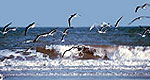
The American Alligator is the most common predator on the refuge that also help control the number of rodents as well as the exotic nutria. This diverse habitat supports 340 bird species and waterfowl in the number of 50,000 use the wetland areas during the fall, winter and early spring months. The city of New Orleans was the recipient of the first US Fish and Wildlife Service Urban Treaty for Bird Conservation grant which educated youth about birds and bird habitat on the refuge.
Bayou Sauvage boasts more than 150,000 visitors annually who have the opportunity to go canoeing, hiking, biking, birdwatching, fishing, crabbing, and crawfishing.

